
A Self-Guided Hawaii Lava Tour Through the 2018 Kīlauea Volcano Eruption

This self-guided Hawaii lava tour itinerary will take you to three sites through the past to relive a time in modern history: the 2018 Kīlauea volcano eruption. But first, the backstory…
The Tale of the 2018 Kīlauea Volcano Eruption
When you think of Hawaii and touring real live lava, it’s Kīlauea volcano. Kīlauea holds the Guiness Book of World Record for being the world’s most active volcano, having flowed continuously for 35 years from 1983-2018.
You can meet the infamous volcano at the unambiguously named Hawaii Volcanoes National Park on the Big Island. Here it is said that Pele, the Hawaiian goddess of volcanoes and fire, makes her residence.

The star attraction inside the park is the summit of Kīlauea. Here sits Halema’uma’u Crater and inside used to be a glowing lake of burning magma. But in 2018, Kīlauea volcano erupted in a surprising and devastating way.
Kīlauea had already been uniquely erupting in two places for the last ten years: the summit of the volcano at Halemau’uma’u Crater and the volcanic cone Pu’u O’o. They sit about 11 miles (18km) apart but they were in tight communication with each other.

Pressure in the magma system began building at Pu’u O’o in March 2018 and signs of it were literally overflowing into Halemau’uma’u Crater: the lava lake level began to rise and spill out into the crater.
On April 30th Pu’u O’o couldn’t handle the pressure anymore and collapsed. In response, two days later the lake of lava at Halemau’uma’u Crater began to drain like an unplugged sink.

The loss of support from the liquid magma underneath the caldera floor caused many earthquakes and collapsing episodes. 26 collapses and 60,000 earthquakes later the crater had deepened from 280 feet (85m) to 1,600 feet (488m) and the diameter had nearly doubled in size to about 2 miles (3km).
But where did the lake of magma drain? It traveled underground for 25 miles until it reached Leilani Estates in Pahoa. On May 3rd the first out of twenty-four fissures opened in the Lower East Rift Zone neighborhood, spilling lava all over the place. Over the next two months, lava covered over 30 miles of road and destroyed 700 homes, displacing 2,000 people (thankfully no deaths). The Big Island also grew by 875 acres of new land.

In September the eruption concluded and the Big Island was forever changed. Popular beaches and tidepools, towns and neighborhoods were buried and gone forever.
Kīlauea has been quiet for the most part since but is still considered an active volcano and could perk up again at any time.
Hawaii Lava Tour Stop #1 – Kīlauea Volcano
- Address: Hawaii Volcanoes National Park 1 Crater Rim Drive Hawaii National Park, HI 96781
- Park hours: open 24hrs a day, 7 days a week.
- Park entrance fee: $30.00 per vehicle, good for 7 days. If the ranger station at the entrance isn’t open there is a self-pay station at the Kīlauea Visitor Center a little ways further. You can put your cash in the box there

Drive-Thru
Start this Hawaii lava tour of the Kīlauea 2018 eruption at the source in Hawaii Volcanoes National Park located at mile 28.5 on Hwy 11.
Get different vantage points of this powerful volcano. Drive the north end of Crater Rim Road. The road used to do a complete loop around the crater but when the crater collapsed in 2018 it took a chunk of the road with it.
Steam Vents

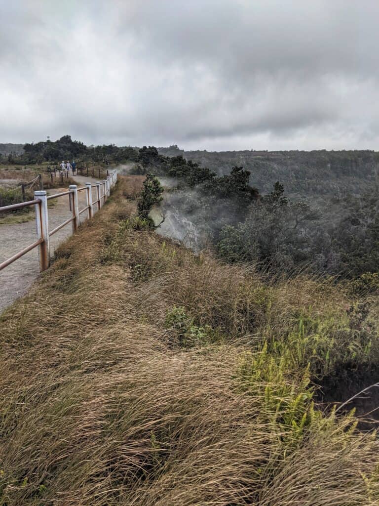
The first stop is at the steam vents to the left. You’ll be able to put your hands and face in the warm steam coming out from this not-so-sleepy volcano. Just a short jaunt from the parking lot gets you to your first viewing of the crater.
Kīlauea makes a melodramatic first impression with its own personal smoke machine (aka steam vents coming out of the cliffs). This show-stopping cavity is a one-man…one-volcano?… show, playing all the parts: the diva, the stage, the backdrop, visual effects, director…

Here you can peek over the edge of the cliff and look down at the cracks and crevices that design the crater floor.
And this is just the first stop; there’s so much more to come!
Further down the road are two more angles of the volcanic profile.
Kīlauea Overlook
Kīlauea Overlook is next. A simple sign reading “Kīlauea” with an arrow pointing left brings you to a parking lot. The view just a short walk away gets you up higher above the crater. You get a better sense of just how massive this hole is. I haven’t been to the Grand Canyon but I imagine there’s some similarity to the Great Awes involved.

Uēkahuna Bluff
Saving the best for last, the unrivaled view is at the end of the road about a quarter-mile further at Uēkahuna bluff, newly reopened since the 2018 eruption. Here you can see the entirety of the vast 2-mile wide caldera. Get your panorama mode set on your camera because you aren’t gonna fit the whole thing in normal mode.

Remember, this is the source of the 2018 flow. From here the lava lake drained away and poured out its contents 25 miles away.
You might meet a ranger here to answer any in-depth questions you have about the volcano.
Hike-Thru
Another way of viewing this massive hole in the ground is hiking the Crater Rim Trail. It is an easy 4-mile roundtrip hike from the visitor’s center to Uēkahuna Lookout. There are many points of access along the trail if you don’t wish to walk the whole length or someone in your party can pick you up/drop you off: Visitor Center, Steam Vents, Kīlauea Overlook, and Uēkahuna Lookout.

The Kūpinaʻi Pali trail, or Waldron Ledge is another easy, paved, and wheelchair accessible portion of the trail and is only one mile roundtrip. This will give you yet another view of the crater and its sense of glory.
You used to be able to hike the caldera floor on the Halema’uma’u Trail. It is currently closed past marker 10 (right before you get to the floor entrance) due to sulfur dioxide gas and the uncertain nature of the volcanic activity.
Once you have gotten a good sense of the magnificence of the crater, what it was and what it is, it’s time to go see firsthand what kind of devastation it caused in 2018.
🌋 Download the Shaka Guide’s Volcanoes National Park Tour
for a complete tour of Hawaii Volcanoes National Park.
Have a personal tour guide in your car as it navigates you via GPS throughout the park.
Hawaii Lava Tour Stop #2 – Leilani Estates
Again, the fissures are about 25 miles away from Kīlauea but you have to drive up and around to get to it. Continue the lava tour by heading east on Hwy 11 then south on Hwy 130. It’s a 35-mile drive that will take about an hour to arrive at Leilani Estates neighborhood.

When you turn onto Leilani Ave, keep going until the road ends at the barrier. There are many-a-warning-sign indicating trespassers could be arrested, so stop here and just observe from afar.

About a half a block down you can see the mound of lava that crosses the road. It’s no joke how high it is. While you can’t see the lava up close here you still get a sense of wonder about it.
It’s also fascinating how fast nature can take over anything in its path. The paved road from the barrier to the lava hill is already half “eaten” by plants uninhibitedly allowed to grow.
Next, backtrack and head south on Kupono St.

You’ll drive over some brightly colored fish painted on the pavement and then you will see Fissure 8 Tours on your left. A house unassumingly sits with a steaming lava mound RIGHT IN ITS BACKYARD!
Notice the sulfuric aromatic notes drifting through the air. Clearly Kīlauea is still conscious and well.

Melissa is the owner of Fissure 8 Tours and amazingly her home was spared even though she is right at Fissure 8, where the predominant amount of lava erupted that destroyed most of Leilani Estates.
You can get in touch with Melissa here to schedule a 2 hour private guided lava tour where she will give you an in-depth educational visit.
OR…
BOOK A 2HR E-BIKE/HIKE TOUR OF FISSURE 8
Bike around Leilani Estates and hike over Fissure 8 with a tour guide showing you the way and telling stories of the incredible 2018 eruption!
➡️ Check Rates and Availability Here!
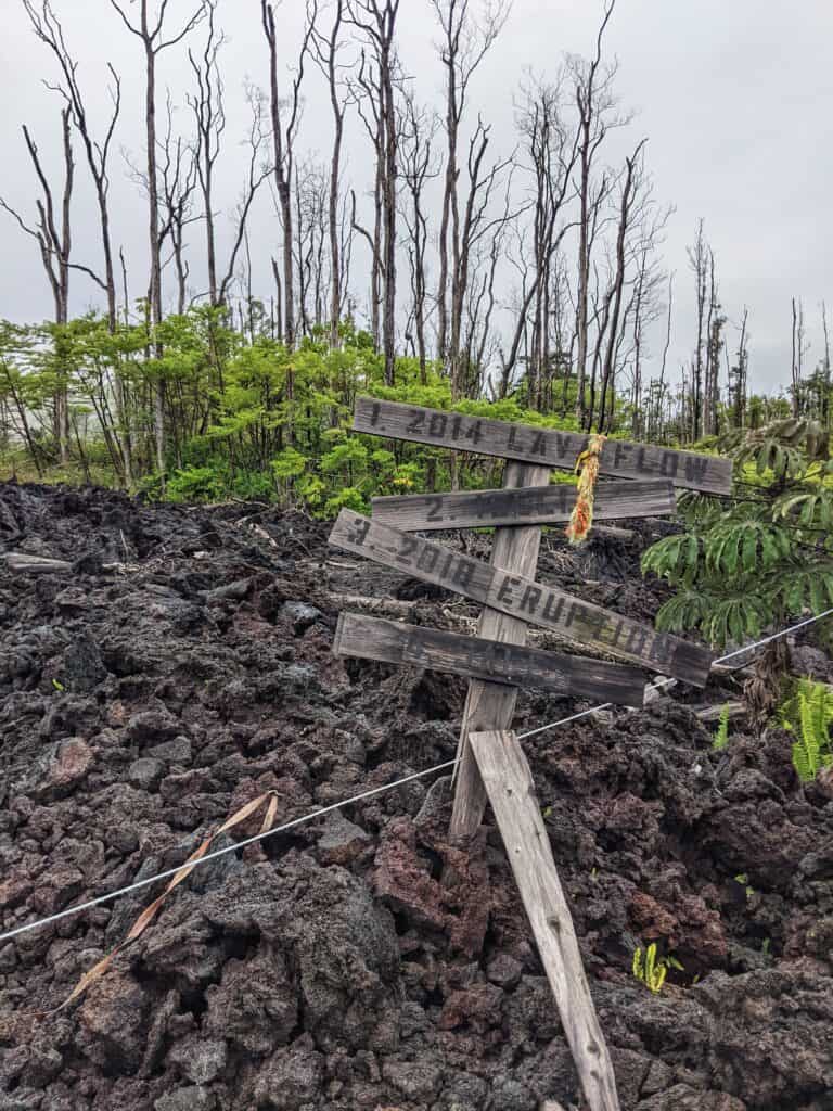
Further down Kupono St the road temporarily becomes gravel because lava had crossed the pavement and had to be cut away. You’ll see piles of a’a lava surround tree corpses to your left and to your right. Steam also billows up among the rocks and through the trees. You can spy yellow spots of sulfur among the lava rocks, and smell it too.

It’s crazy to see the juxtaposition of death and life living next to each other with the lava sitting amongst rainforest foliage. And just like tornadoes can destroy one house but spare its neighbor, you can see the lava field pass the same judgement, or mercy, on one house but not the other.

You can drive around to other corners of the neighborhood to see additional pockets of destruction but most of the side streets that were affected by the lava are closed off for residents only.
Hawaii Lava Tour Stop # 3 – Isaac Hale Beach Park
- Address: 13-101 Kalapana Kapho Beach Rd Pahoa, HI 956778
- Park hours: 7:00a-6:40pm
- Entrance fee: FREE

The last stop on this Hawaii lava tour through modern history ends at the beginning…of the future of the Big Island.
The 2018 lava flow still covers Pohoiki Rd so you have to take the long way around, 12 miles and about 30min, to get to Isaac Hale Beach Park. Continue south on Hwy 130 until you reach the end and head east on Hwy 137.
You will drive across the rollercoaster-esque pavement and through the lush Malama-Ki Forest Reserve (the magical, tropical roads of your dreams) which will suddenly open up to a couple of 2018 lava fields. The road has been cut through and laid with gravel so it’s still traversable. You can look up the fields and see dead trees resting on top of the lava that killed them.

Once you’ve wound your way through the jungles the road ends (again, because of the lava flow) at Isaac Hale Beach Park.
Pohoiki Black Sand Beach
And why are you here, you ask? Whelp, here lies Pohoiki Black Sand Beach, a new black sand beach that is forming with remnants of the 2018 Kīlauea volcano eruption.
Black sand is formed when hot lava hits the ocean, cools down quickly, and explodes into pieces that wash up onto the shore. As the waves crash over and over again the fragments get ground into sand.

The 2018 flow stopped short of filling up Pohoiki Bay, 230ft from the harbor. You can see the contrasting dark lava rocks that flowed into the ocean and the new, lighter black rocks/sand getting created on shore. The black sand is more coarse and rockier than what you think of as sand, but the waves are still working at grinding it into a fine sand.
The boat ramp that used to be a busy take-off point for volcano boat tours and fishing boats is now buried in this new black sand, creating a ghost town, or rather a ghost harbor.

The future of this bay is uncertain for a couple of reasons. One is that black sand tends to disappear if it’s not being replenished with new lava, so unless another eruption happens in this same area there won’t be new lava coming. Second, because this was the only boat launch in the Puna district they may rebuild it so locals can return to their main source of oceanic income, but that will impact the geography of the new beach. So enjoy it now for we know not what the future holds.
For another black sand beach be sure to visit Punalu’u Black Sand Beach.
Pohoiki Warm Spring and Ocean Thermal Ponds
A unique and special way to visit this park is to bathe in the geothermal ponds. The new black sand beach has created a few warm springs (because they aren’t hot enough to be hot springs). You can wade in these natural warm baths in a couple of spots.
You’ll see the first ponds by the boat ramp and a little beyond by the tree line. These are the newer ponds created by the building up of the black sand beach. They aren’t very deep and are at a comfortable 75-85°F (24-29°C), depending on the tide and time of day.

While not completely dangerous, there are warning signs to swim at your own risk. Don’t go in if you have open cuts as there may be bacteria in the water.

Further back into the trees is the original pond, Pohoiki Hot Springs, which was formed by a collapsed lava tube. Here the water is warmer and deeper than the other ponds and you are set in the middle of the lush forest instead of on the rocky beach.
What a relaxing way to end your day of historical lava themed touring!
BONUS: Sleep at Kīlauea Volcano
Level up your Hawaii lava tour by staying in Hawaii Volcanoes National Park at the Volcano House in one of their Volcano Crater View Rooms.
You read that right! A room with a personal view of the crater! What a way to kick off this historic geological excursion of Kīlauea volcano.
>> Check Rates and Availability for a Room at the Volcano House Here! <<

Learn About More Volcano Sites on the Big Island:
Hawaii Volcanoes National Park
Kahuku Unit
Mauna Loa Scenic Road
🌺 Big Island Travel Planning Guide 🌺
🚨 Should I buy Hawaii travel insurance?
YES — I recommend Travel Insurance Master because you can compare multiple options with one click. With plans starting at $5/day per person, why not give yourself piece of mind? Better to have it and not need it than need it and not have it!
🚗 Is it safe to rent a car on the Big Island?
YES — It’s totally safe to drive on the Big Island. And unless you plan to chill by the resort pool the entire time, renting a car is pretty much a necessity on the Big Island! Jeep rentals are popular. I recommend Discount Hawaii Car Rental, as they have some of the best prices around.
📞 Will my phone work on the Big Island?
PROBABLY — Most, if not all, cell providers work on the Big Island. However, be prepared for some dead spots in the more remote parts of the island. For example, I always lose service driving through Hawaii Volcanoes National Park.
🛏️ What’s the best way to book my Big Island accommodations?
For Big Island hotels, Booking.com is amazing because you can often reserve your room with no money down. If you are looking for an Airbnb condo with a kitchen and more space, don’t forget to check VRBO for potentially better prices and options.
✈️ What’s the best site to buy Big Island flights?
I recommend looking at Skyscanner for finding cheap flights. Pro Tip: check if flying into Hilo is cheaper than flying into Kona.
🛂 Do I need a passport to visit Hawaii?
NO — If you are a US citizen, you do not need a passport as Hawaii is part of the United States. If you are from out of the country, the same passport and visa requirements are the same as entering anywhere in the United States from your country.
🧳What should I pack to the Big Island?
Pack for tropical weather but also prepare for colder than expected nights and early mornings, so a light sweatshirt is recommended. Check out this list of 5 Things Not to Forget to Pack.


